
![]()
Get walking with Weber Walks!
You can use our resources to walk around campus alone, or join a group to meet new people and make moving a bit more fun!
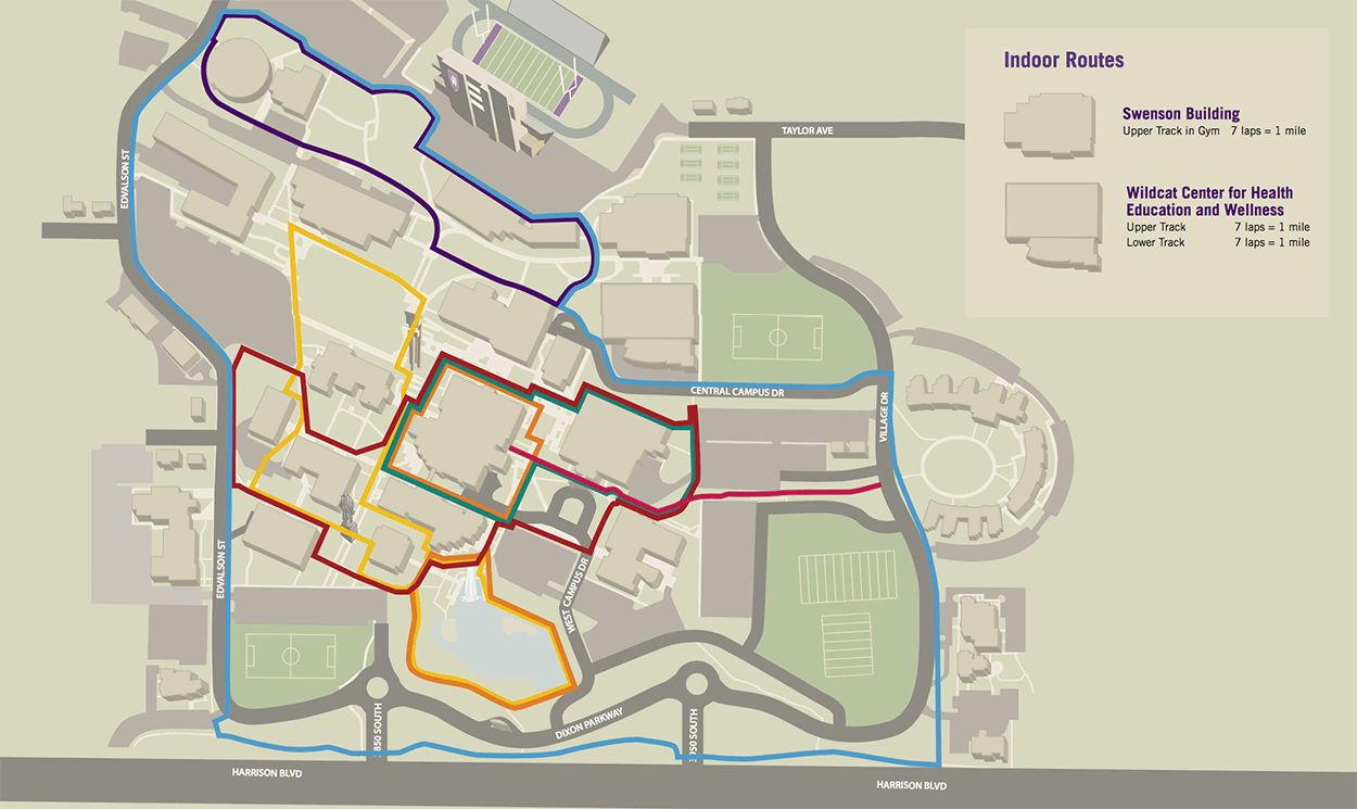
ORANGE ROUTE - 1/3 MILE
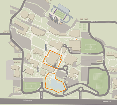
- Duck pond – 1 mile = 3 times around upper track
- Union Building – 1 mile = 3 times around, following sidewalks
PINK ROUTE - 1/2 MILE (OUT AND BACK)
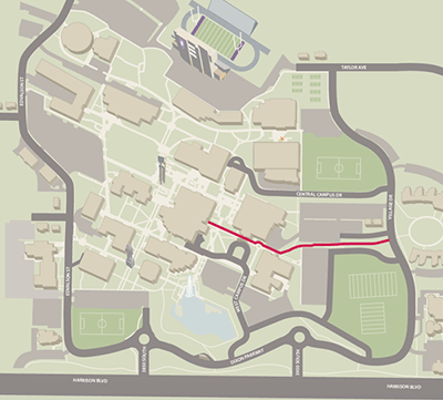
- Start at the main entrance of the Union Building on the north side of the building
- Head south along the sidewalk, past the Browning Center and out to the cross walks on Village Drive
- Turn around and head back to the Union Building
TEAL ROUTE - 1/2 MILE
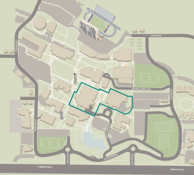
- Start at the picnic tables at Veteran’s Grove, next to the W7 lot
- Head west along the sidewalks towards the Kimball Arts Center
- Cut between the Kimball Arts Center and the Browning Center. Continue along, in front of the Browning Center, towards the Student Union
- Turn west and loop around the Union Building
- Follow the sidewalks between the Union Building and the Library, continuing along between Lampros Hall and the east end of the Browning Center
- End back at Veteran’s grove
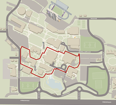
PURPLE ROUTE - 1 MILE
- Begin at the benches behind the Stewart Library
- Walk southwest along the sidewalk behind the library towards the shuttle station
- At the shuttle station, head east towards the Marriot Health building
- Take the stairs on the south side of the Marriot Health building up to the A6 lot
- Turn left and head northeast along the sidewalks on the west end of the parking lot toward the Lind Lecture Hall
- Loop around the Lind Lecture Hall toward the A4 lot
- Continue along the available sidewalks, past the Technical Education and Engineering Technology buildings
- End back at the Stewart Library
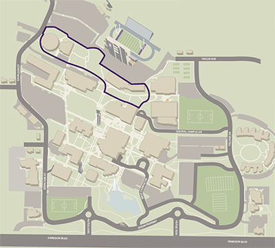
RED ROUTE - 1 MILE
- Start at the picnic tables at Veteran’s Grove, next to the W7 lot
- Head west along the sidewalks towards the Kimball Arts Center
- Turn and head towards the Browning center
- At the Browning Center, turn and follow the sidewalks west towards West Campus Drive
- Turn north and follow the sidewalks along the paid lot
- Turn west by the Student Services Building, toward the duck pond
- Loop around the Miller Administration Building, following the sidewalks toward Social Sciences Building
- Turn east on Edvalson and head up to the A2 lot
- Turn south towards Elizabeth Hall
- Cut between Elizabeth Hall and the McKay Education Building
- Follow the sidewalk in front of the Business Building
- Connect with the center campus sidewalk and turn southeast towards the Union Building
- Follow the sidewalks between the Union Building and the Library, continuing along between Lampros Hall and the east end of the Browning Center
- End back at Veteran’s grove
YELLOW ROUTE - 1 MILE
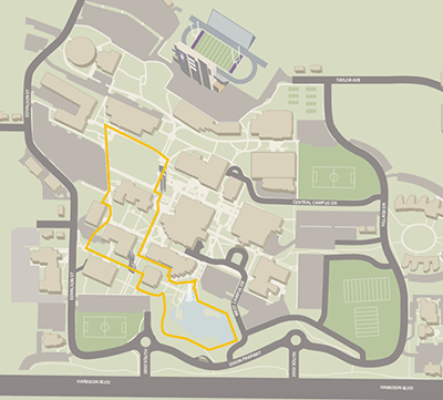
- Begin at the Bell Tower
- Head down the center of campus sidewalk
- Turn left on the sidewalk between the Student Service Center and the Miller Administration Building
- Follow the path counterclockwise around the pond, one time
- Take the sidewalk west of the Miller Administration Building
- Cut between the Social Science Building and the Wattis Business Building
- Go up the stairs on the north side of the Wattis Business Building
- Follow the sidewalk on the north end of Tracy Hall to the Engineering Technology Building
- Turn north, past the Engineering Technology Building and back to the center of campus sidewalk
- Follow the wheelchair ramp in front of the library End at the Bell Tower
BLUE ROUTE - 1.75 MILE
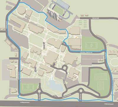
- Start at the Shuttle station by Stewart Library
- Head east, taking the stairs and sidewalks past the Wildcat Center, and Swensen Buiding to the A6 lot
- Turn northeast and follow the sidewalks on the west end of the parking lot toward Edvalson Street
- Follow the sidewalks on Edvalson
- Cross the street at the Institute Building
- Continue along Edvalson to the bottom of campus
- Cross over to the sidewalk along Harrison Blvd. at the Police Station
- Head south along the sidewalk on Harrison to the Credit Union
- Turn east and follow the sidewalks along Village drive to Central Campus drive
- Cross at the crosswalk and follow the sidewalks on Central Campus drive back to the shuttle station